
Official Map
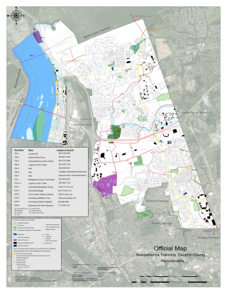
As part of the continuing work of implementing our Comprehensive Plan, Sustainable Susquehanna 2030, Susquehanna Township has developed an Official Map and associated Ordinance. The Board of Commissioners adopted the map and ordinance on February 11, 2021.
What is an Official Map?
An Official Map is a combined map and ordinance that identifies the location of planned public lands and facilities. It is an official declaration by the governing body of a municipality’s interest in acquiring private lands for public purposes sometime in the future. Public purposes may include proposed streets, parks, open spaces, trails, transit routes, and flood control and stormwater management facilities Official Maps can be used by cities, boroughs, townships, and counties An Official Map is a land use ordinance authorized by the PA Municipalities Planning Code, Article IV It is not to be confused with a municipal base map, street map, or zoning map, or maps in a municipal comprehensive plan. (Source: PA DCED)
How Does an Official Map Work?
The enactment of an Official Map ordinance serves as notice of reservation of land for future public use. An Official Map gives a municipality an opportunity to acquire property, or rights thereto, for public use before development or redevelopment occurs, and does not itself constitute a municipal taking of private property. Once a property owner notifies a municipality of intention to subdivide or develop land that is identified on an Official Map, the municipality has one year to either purchase the land, come to an agreement with the developer, condemn the land through eminent domain, or choose not to pursue the acquisition The municipality is not obligated to build the facilities shown on the Official Map. In cooperation with the municipality, the developer may decide to construct the improvement shown on the Official Map. (Source: PA DCED)
| Attachment | Size |
|---|---|
| 274.05 KB | |
| 2.7 MB |